
| Join Our Mailing List |
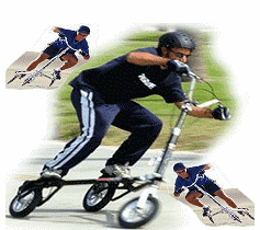
Trikke Trail Scout
The trikke is great for
exploring.
Light, easy to fold up for your car.
Unlike your bike, no need for racks, or removing parts to take on your
travels.
Even when you stop for a break traveling, stretch your legs at the rest
area, get a short workout.
Areas to explore on your Trikke
Jacksonville, FL Baldwin Rails-to-Trails
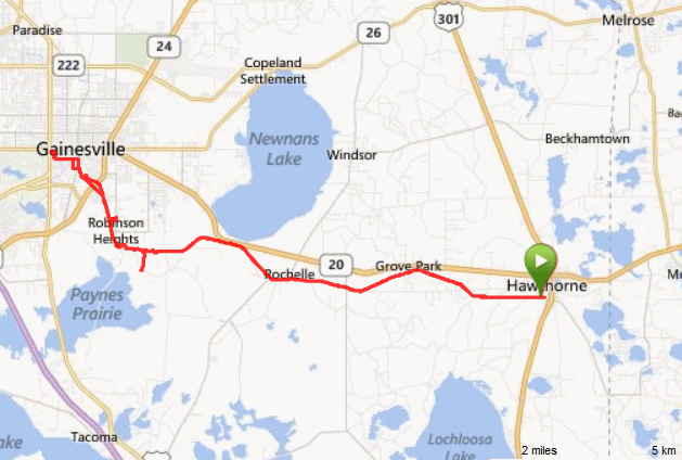
Hawthorne, Fl Trail ride
...about 2 hrs from JAX
Trikke Virginia by
BJ a Trikke Certified Class III Trainer
These 1st contributions are by Dee.
She has spent time exploring some places for ridding your trikke .
Share your ride by mapping it and emailing me the link and some details about
the ride. Pictures too !
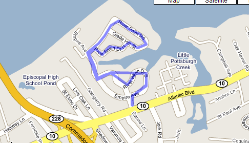
| First Coast ... Jacksonville, FL Local Rides |
| Click on link below or map to see the
active map Try out your hill climbing here ! Near Atlantic Blvd and the Hart Bridge 1.9 miles Some interesting history too from Dee ! This was Dee's first attempt, don't laugh. Didn't mean to shoot across private property on the way back! This is the one by the EAP/Wellness office that is so hilly. There are a couple water views as many of the homes are waterfront.
Are you talking about the big white house with the turret, like a
castle, that has a long pool out front (4749 River Point Road)? If
so, that's known as "Marabanong," a New Zealand Maori Indian word
for "Paradise." I had the privilege of touring that home many years
ago when it was the Designer Showhouse. The Trouts bought it in
1914 and members of the Trout family (Trout Real Estate) continued
to own it until 1983, when it was sold. It was during the Trout
rein that I toured it.
The big white house with the turret, like a castle, that has a long
pool out front (4749 River Point Road)? If so, that's known as
"Marabanong," a New Zealand Maori Indian word for "Paradise." Dee
toured that home many years ago when it was the Designer Showhouse.
The Trouts bought it in 1914 and members of the Trout family (Trout
Real Estate) continued to own it until 1983, when it was sold. It
was during the Trout rein that I toured it.
Construction of Marabanong began sometime around 1876 on this site, where a previous home that had stood for 20 years had been burned to the ground. The owner of the burned one, Thomas Basnett, was a noted astronomer from England. Basnett is the one who constructed this mansion. Basnett married Eliza Wilbur, an internationally known scientist from New York. Both of them were prolific authors of scientific articles, books and magazines. She patented a large astronomical telescope while she lived there and was designing an airplane at the time the Wright brothers made their first flight. After Thomas died, Eliza married a French physician who was a throat and lung specialist. When he was there, he advertised their home as a resort for folks needing special attention and offered them free transportation to his home/resort via steamboat from downtown. He died in 1914, and that's when the Trouts took over.
While the Trouts were there, they maintained a zoo including
crocodiles, pheasant and peacocks, which delighted their many
Northern visitors. Marabanong's once-spacious riverfront property
is now divided with a number of single-family residences. It's
two-story veranda is Jacksonville's most impressive porch. The
house is 6,000 square feet, with 21 rooms, 5 baths and 121 windows.
It's most intriguing feature is a brick structure built into the
bluff in front of the house (on the river side). Thought to be a
wine cellar, it was built before the Civil War and was once
connected to the kitchen by an underground passageway. It is the
only part of the original 1850 construction that survived the fire
almost 130 years ago.
There's a big house with columns at 4915 River Point Road. It's not
brick, though, it's wood, but you may have thought it was painted
brick. In 1850 the first circular steam sawmill in Florida was built
at the mouth of Pottsburg Creek. After the Civil War (in 1876), the
old Empire Mill site was sold to Alexander S. Diven, a general in
the Union Army and Congressman from New York. Apparently, he was
just one of many Northerners who settled along the southern bank of
the St. Johns River after the War. The house was built around 1877,
and the property contained 34 acres at that time. The timbers used
to construct the house are huge, some 10" by 12". They were taken
from the log pond next to where the old mill had been. The
foundation and chimney are made from bricks that were made at the
claypit one-quarter mile from the homesite. General Diven started a
grove of 700 orange trees on this site, with their own irrigation
system. This grove continued until 1952, and the last of these
trees was killed by the Christmas Freeze of 1983. I don't know if
you were in Jacksonville then, BJ, but it snowed and school was
out for days due to power outages and icy streets. Major Joseph
Durkee, another Union officer, was County Sheriff, State Senator,
and railroad executive. His son, Dr. Jay Durkee bought this home in
1909 from General Diven's son. in 1952, Major Durkee's grandson
developed the adjacent 90 acres into a subdivision and named
it "Empire Point," after the area where his old family home still
stands.
Another old home with not such a colorful history is at 1231
Glengarry Road. It was built around 1872. It's site was originally
18 acres. A congressman from New York, commander of Union troops,
and Minister to Japan from 1866 to 1869, Robert Van Valkenburg
bought this site around 1871. He and his wife decorated it with
furniture they had collected in Japan.
|
Click on the Thumbnail to see the brick stucture built on the bluff - river side of the house.
|
Some Hill Climbing Challenges right here in Jacksonville. Not recommending this for beginners, because I think you will be doing a lot of walking up hills here. Very nice old neighborhood on the St. John's River You can extend the ride by continues the loops ! Great Hill Climbing workout !
With MotionBase you can see the elevations - speeds I reached on Christmas Day 2007 -- the road was wet too.
![]()
|
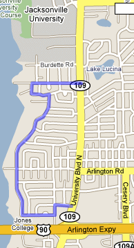
Click on link below or map to see the active map Arlington Area 2 miles The north end of the trail begins on University Boulevard North at Floral Bluff, just south of the Boys Home and JU. You may park your car in the large lot across from Floral Bluff which is between Angelo's Italian Restaurant and The Cottage Consignment.
This is a delightful, quiet residential
neighborhood trail with some twists and turns and a few hills. Be
careful at the foot of the hill at Arlington Road. There's a stop
sign there, where the boat ramp is! Then there is an uphill grade
on the other side of Arlington Road. Lots of trees and interesting
mid-century homes on the river side.
At the end of two-miles, on the southern
end of the trail, you will find yourself in the parking lot of the
Compass Bank on University Boulevard, near the exit to Arlington
Expressday. You may also choose to begin your ride here, but I
would pick a time when the bank is closed!
Dee
|
 |
These 2 rides are close and could be combined for a 8 mile ride.
|
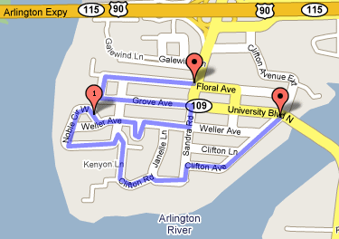
Click on link below or map to see the active map Arlington Area 2 miles Arlington AreaThis trail winds through an area that used to be known as "Arlington Bluff." John Sammis, a New York ship builder, bought 6,000 acres in this area in 1839. If you try this trail, don't miss the two-story home built in the 1850s at 207 Noble Circle West. This was the first home on the bluff. Can you imagine the view, unobstructed by the other homes that have since been added? John Sammis lived here with his wife, Mary, and their children for 20 years. Mary was the younger daughter of Zephaniah Kingsley, of the Kingsley Plantation. Her mother was Kingsley's African wife, Anna Jai. Sammis and most of his family are buried in the small cemetery at Magnolia and Garrison, which you will see on your ride. In 1873, the Sammis family moved to Mandarin, and the house was sold to a church colony, which used it as a resort for its members and added a large two-story wing containing guest rooms. The church colony folded in less than a year, and the property was bought by William Matthews (the Matthews Bridge), a real estate developer. It continued to be used as a hotel for many years. In 1909 Matthews' granddaughter married and they took over the residence. They remodeled it extensively. The hotel addition was removed in the 1950s.
Other historic homes that can be seen in
this area are:
|
 |
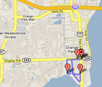
| Click on link below or map to see the
active map Orange Park Ride 8 - 10 miles You can park near Cracker Barrel to begin. It's two miles, all riverfront, 'til the foot of Kingsley, where you are forced to turn right. One could turn around then and head back for a four-mile trip. Or, continue down Kingsley, where there's a designated bike trail, until you reach Doctors Lake Drive. Get on the bike path for an additional 5+ miles, one way. If you wanted to begin a trip at Doctors Lake Drive, there are plenty of business along there where you could park. Then your ride would be 10 miles, round trip. You could plan it so that if you wanted to, you could eat at Grumpy's Cafe, near the Kingsley & Drs Lake intersection, or the Dairy Queen, which is also close by, or Cracker Barrel. Dale and I usually like to combine a bicycle trip or boat trip with a meal before we head back home.
|
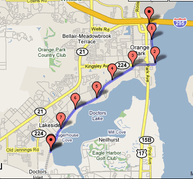 |
| Click on link below or map to see the
active map Doctors Lake Area 3 - 9 miles Here's one where you can start from the parking lot at Winn-Dixie on Park at Kingsley. It's a 3-mile round trip and could be combined with the 2-mile riverview for anyone wanting to get about 8 or 9 miles in. |
 |
Baldwin Rails-to-Trails
Jacksonville, FL a 34 mile ride round trip
Click here
to see my ride on Garmin Connect
Parking & Trail Access:
Imeson Road Trailhead: From Jacksonville, take Interstate 10 west
to Exit 53 (new Exit 356) for Interstate 295. Head north on I-295 to
Commonwealth Avenue (Exit 9). From Exit 9, head west on Commonwealth Avenue
approximately 1 mile to Imeson Road. Take a right on Imeson Road (heading
north) and continue to the trailhead.
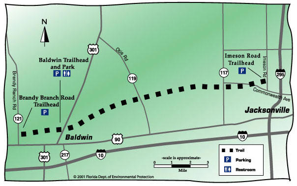
Baldwin Trail
Half way point at
Camp Milton Access
by starting here and going west you don't have many
inclines to challenge you
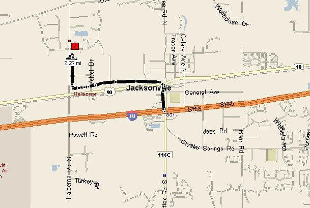
The Hawthorne Trail is in Hawthorne, Fl . about 2 hrs from Jacksonville
.gif)
.gif)